Classbaze

Disclosure: when you buy through links on our site, we may earn an affiliate commission.

Groundwater Potential Zones GIS – Complete Project ArcGIS

Also covers, Flood Risk Map, Drought Analysis, Fluctuation from Observed data, Watershed Delineation, Tutorial in depth
4.5
4.5/5
(239 reviews)
972 students
Created by

9.1

Classbaze Grade®

8.2

Freshness

9.5

Popularity

9.1

Material

Also covers
Platform: Udemy
Video: 3h 48m
Language: English
Next start: On Demand

Best GIS classes:

Classbaze Rating

Classbaze Grade®

9.1 / 10

CourseMarks Score® helps students to find the best classes. We aggregate 18 factors, including freshness, student feedback and content diversity.

Freshness

8.2 / 10
This course was last updated on 11/2020.

Course content can become outdated quite quickly. After analysing 71,530 courses, we found that the highest rated courses are updated every year. If a course has not been updated for more than 2 years, you should carefully evaluate the course before enrolling.

Popularity

9.5 / 10
We analyzed factors such as the rating (4.5/5) and the ratio between the number of reviews and the number of students, which is a great signal of student commitment.

New courses are hard to evaluate because there are no or just a few student ratings, but Student Feedback Score helps you find great courses even with fewer reviews.

Material

9.1 / 10
Video Score: 8.1 / 10
The course includes 3h 48m video content. Courses with more videos usually have a higher average rating. We have found that the sweet spot is 16 hours of video, which is long enough to teach a topic comprehensively, but not overwhelming. Courses over 16 hours of video gets the maximum score.
The average video length is 5 hours 07 minutes of 88 GIS courses on Udemy.
Detail Score: 9.6 / 10

The top online course contains a detailed description of the course, what you will learn and also a detailed description about the instructor.

Extra Content Score: 9.5 / 10

Tests, exercises, articles and other resources help students to better understand and deepen their understanding of the topic.

This course contains:

0 article.
2 resources.
0 exercise.
0 test.

In this page

About the course

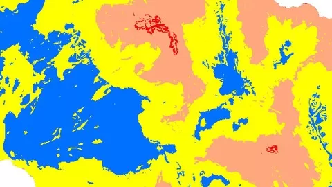
This course covers everything from basic to final results. It starts from Google Search data Download and process data till last result. it also covers the  use of  available  online data sources to prepare Groundwater. It covers all Practical aspects till final results. Only you need to have land use map  ready before starting of this course.  Rest of things covered in this course from basic. You no need to go anywhere outside of you room to run this project. But if you have observation data then you can generate fluctuation map also, that is optional part of this project. By using GIS it is also possible to generate groundwater maps without groundwater data also. But this data is not easily available. So, while performing groundwater potential zone analysis we not used observed data it is optional. Observed data covered in other section of this course for fluctuation map analysis. The data, which used for Groundwater analysis, same data can be used for other analysis also, like Flood risk, Drought prone area analysis. So this analysis are also performed in this course. Because data is same just difference of value.  You will also learn data plotting. This project also covers watershed Delineations.  If your study area is not watershed, just use study area boundary and skip watershed delineation.  Therefore, it covers more than it specified. You by taking this course you not only learn groundwater, you will learn many more advanced task of GIS also, Like DEM mosaic, Data Re-Project , Cutting of study area, soil map generation etc. Therefore, This is complete project from scratch. Feel free to ask me question in Q&A Section. I assumed you know very basic of GIS to perform this analysis.  This is Expert level work.
This course is in Full HD 1080p for better Experience use Setting to HD and headphones.
Only take this course if you know basic of GIS. You must have landuse landcover file before processing to this course.

What can you learn from this course?

✓ Successfully identify Groundwater Potential Zones
✓ Also Drought prone Area analysis
✓ Flood Risk map
✓ Working with Rainfall Data
✓ Generate Soil Map and identify Soil Properties
✓ Delineate Watershed
✓ Drainage Density and Drainage Maps
✓ Mosaic of Digital Elevation Model
✓ Area Calculation from Pixels
✓ Data Interpolation
✓ Adding Data from Excel to GIS Environment
✓ Perform GIS data calculations
✓ Tool used for Site suitability analysis
✓ Working with CDF file and data Extraction, Map Generation, Calculation,
✓ Data Reclassification
✓ Generate Fluctuation maps to identify Good Aquifer.
✓ Data Reproject
✓ Calculation with Raster Data
✓ Data management in GIS

What you need to start the course?

• Basic GIS
• Must have Landuse image
• You must have ArcGIS any Version

Who is this course is made for?

• GIS Student
• GIS Professionals
• Professors
• Scientists
• Master Student of Remote Sensing and GIS
• PhD Research Scholars
• Groundwater Exploration Engineers
• Irrigation Engineers
• Water Resource Engineers
• Students of WRDM
• Govt Policy Makers
• Ministry of Earth Science

Are there coupons or discounts for Groundwater Potential Zones GIS - Complete Project ArcGIS ? What is the current price?

The course costs $14.99. And currently there is a 67% discount on the original price of the course, which was $44.99. So you save $30 if you enroll the course now.
The average price is $14.0 of 88 GIS courses. So this course is 7% more expensive than the average GIS course on Udemy.

Will I be refunded if I'm not satisfied with the Groundwater Potential Zones GIS - Complete Project ArcGIS course?

YES, Groundwater Potential Zones GIS – Complete Project ArcGIS has a 30-day money back guarantee. The 30-day refund policy is designed to allow students to study without risk.

Are there any financial aid for this course?

Currently we could not find a scholarship for the Groundwater Potential Zones GIS - Complete Project ArcGIS course, but there is a $30 discount from the original price ($44.99). So the current price is just $14.99.

Who will teach this course? Can I trust Lakhwinder Singh?

Lakhwinder Singh has created 6 courses that got 1,467 reviews which are generally positive. Lakhwinder Singh has taught 4,435 students and received a 4.5 average review out of 1,467 reviews. Depending on the information available, we think that Lakhwinder Singh is an instructor that you can trust.
Ph.D Research Scholar in GIS with Water Resources App
I completed PhD at IIT Roorkee. I have wide Experience of GIS more than 12 years. I have developed my Own Models, Online Apps. Performed Automated task in GIS for faster Project management. I did many real projects for Govt. Like planing of the lake. Discharge Simulation, Soil Erosion, Sediment model development and analysis. Research is published in International Journals. You can find me on Research-gate also. I answer GIS Queries around the world with my GIS Facebook page followed by 25k and Youtube followed by 48k. and running worldwide GIS discussion group with 50k Expert of GIS around the world. Even I have a free Basic tutorial website. I also taught GIS course for Govt Engineers sponsored by Govt with real-life problems and discussion. So I have wide Experience of the teaching of GIS. I know how to teach difficult task in an Easy way.  I am providing a course at my own place to student around the world. Including Nepal, India, Ghana, Ethiopia, Zambia, South Africa, etc  At my own place I teaching full GIS course from Basic to Advanced covering 124 topics. My student required just basic knowledge of computer and they will become GIS Expert at End of Course. 
Received International Award for Best SWAT Support, from Texas A&M University, USA and USDA at Brussels, Belgium
All course 90% practical 10% theory 
My training Method of Different than All others. More user friendly from practical Examples. I know how our brain learns scientifically.
Browse all courses by on Classbaze.

9.1

Classbaze Grade®

8.2

Freshness

9.5

Popularity

9.1

Material

Platform: Udemy
Video: 3h 48m
Language: English
Next start: On Demand

Classbaze recommendations for you