Classbaze

Disclosure: when you buy through links on our site, we may earn an affiliate commission.

Server-side web GIS applications with Leaflet and PostGIS

Accessing common data stores
4.7
4.7/5
(218 reviews)
2,000 students
Created by

8.7

Classbaze Grade®

7.0

Freshness

9.1

Popularity

9.4

Material

Accessing common data stores
Platform: Udemy
Video: 16h 39m
Language: English
Next start: On Demand

Best GIS classes:

Classbaze Rating

Classbaze Grade®

8.7 / 10

CourseMarks Score® helps students to find the best classes. We aggregate 18 factors, including freshness, student feedback and content diversity.

Freshness

7.0 / 10
This course was last updated on 11/2019.

Course content can become outdated quite quickly. After analysing 71,530 courses, we found that the highest rated courses are updated every year. If a course has not been updated for more than 2 years, you should carefully evaluate the course before enrolling.

Popularity

9.1 / 10
We analyzed factors such as the rating (4.7/5) and the ratio between the number of reviews and the number of students, which is a great signal of student commitment.

New courses are hard to evaluate because there are no or just a few student ratings, but Student Feedback Score helps you find great courses even with fewer reviews.

Material

9.4 / 10
Video Score: 10.0 / 10
The course includes 16h 39m video content. Courses with more videos usually have a higher average rating. We have found that the sweet spot is 16 hours of video, which is long enough to teach a topic comprehensively, but not overwhelming. Courses over 16 hours of video gets the maximum score.
The average video length is 5 hours 07 minutes of 88 GIS courses on Udemy.
Detail Score: 8.8 / 10

The top online course contains a detailed description of the course, what you will learn and also a detailed description about the instructor.

Extra Content Score: 9.5 / 10

Tests, exercises, articles and other resources help students to better understand and deepen their understanding of the topic.

This course contains:

0 article.
17 resources.
0 exercise.
0 test.

In this page

About the course

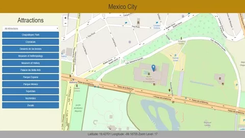
Server-side web GIS applications allow you to access GIS data stored in a multi-user database. This means that your data will always be current and any changes that other users make to the data will be immediately available in your application. You will be able to build complex GIS applications where some users will only be able to view certain data that you allow them and other users will be able to add, edit, and delete data from a web-interface. This means that your users will be able to interact with your GIS database from any device that has a compatible browser and an internet connection. They may be working in the field from a mobile device or from home on a mac OS computer, or on the other side of the world on a Linux computer.

This course uses PHP for the server-side language because of its popularity and its wide availability on web servers. We will use PostGIS as a spatial database, again because of its popularity and common usage in GIS applications. I teach standard web development methods that have stood the test of time and will still be available in many years after the latest, greatest, technology has been replaced with something even better. My goal as an instructor is to provide an introduction to the basic concepts. I don’t think you will find any limitations with the software that I teach but if you ultimately decide to use a different server-side language, database, or a newer framework the methods you learn here will provide a solid foundation.

Best of all, this course uses all open source software so there are no costs involved. I have had projects involving more than 50 people, including clients, accessing the same database through web interfaces and desktop GIS for several years with no problem and with no cost other than web-hosting which cost us about $10/month total. 

What can you learn from this course?

✓ Develop complex web GIS applications using data stored in a PostGIS database with open source software that doesn’t require any licensing fees or subscriptions.

What you need to start the course?

• Basic web development skills (HTML, CSS, and JavaScript)
• Basic understanding of web mapping with leaflet
• Basic understanding of databases and SQL
• The above can be learned in my courses “Display and analyze GIS data on the web” and “PHP registration, login, and content management system”
• Highly recommended course: “Introduction to spatial databases with PostGIS and QGIS

Who is this course is made for?

• GIS professionals who are interested in expanding their skillset from producing static web maps to creating web GIS applications that allow creation and deletion of GIS data from the web.

Are there coupons or discounts for Server-side web GIS applications with Leaflet and PostGIS ? What is the current price?

The course costs $14.99. And currently there is a 82% discount on the original price of the course, which was $84.99. So you save $70 if you enroll the course now.
The average price is $14.0 of 88 GIS courses. So this course is 7% more expensive than the average GIS course on Udemy.

Will I be refunded if I'm not satisfied with the Server-side web GIS applications with Leaflet and PostGIS course?

YES, Server-side web GIS applications with Leaflet and PostGIS has a 30-day money back guarantee. The 30-day refund policy is designed to allow students to study without risk.

Are there any financial aid for this course?

Currently we could not find a scholarship for the Server-side web GIS applications with Leaflet and PostGIS course, but there is a $70 discount from the original price ($84.99). So the current price is just $14.99.

Who will teach this course? Can I trust Michael Miller?

Michael Miller has created 19 courses that got 5,705 reviews which are generally positive. Michael Miller has taught 15,756 students and received a 4.5 average review out of 5,705 reviews. Depending on the information available, we think that Michael Miller is an instructor that you can trust.
GIS Programming
I have been programming and working with database applications for over 30 years, and specializing in geospatial applications for over 20 years.  I am a believer in the 80/20 pareto principle which suggests that you only need to understand 20% of a subject in order to do 80% of your work. My goal in all my courses is to teach at the level of that 20% sweet spot and to provide my students with the background and the tools they need to learn the rest of what they need on their own.
Browse all courses by on Classbaze.

8.7

Classbaze Grade®

7.0

Freshness

9.1

Popularity

9.4

Material

Platform: Udemy
Video: 16h 39m
Language: English
Next start: On Demand

Classbaze recommendations for you